
↓
 

Bowling Green Land Surveying

Local Land Surveyors in Bowling Green, KY

Bowling Green Land Surveying
(270) 282-7273
Bowling Green Land Surveying
  • Home
  • ALTA Survey
    • Bowling Green, KY
    • Lexington, KY
    • Louisville, KY
    • Clarksville, TN
    • Nashville, TN
  • Boundary Surveying
  • Construction Survey
  • Drone LiDAR Mapping
  • Elevation Certificate
  • Land Surveying
  • Lot Survey – Closing Survey
  • Topographic Survey
  • Blog
  • Contact Us
Home - Page 2 << 1 2 3 4 … 7 8 >>

Post navigation

← Older posts
Newer posts →

When a Perc Test Becomes Necessary for Rural Landowners

Bowling Green Land Surveying Posted on June 11, 2026 by Bowling Green SurveyorJune 8, 2026
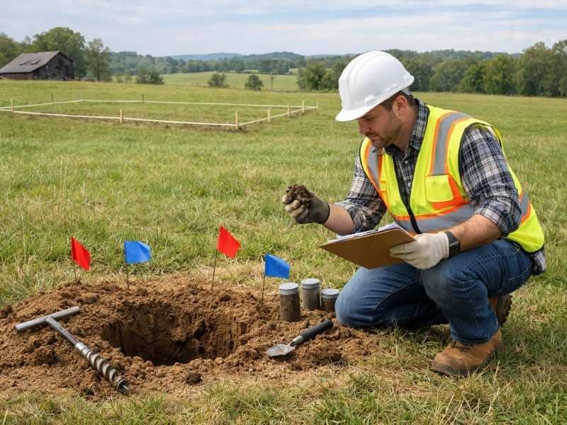
A soil specialist performs a perc test on rural land, examining soil conditions for a future septic system and home site

If you’re buying or building on rural land near Bowling Green, Kentucky, and the property doesn’t connect to a public sewer, you’ll need a perc test before you can move forward with construction. It’s not optional. In Kentucky, a perc test is required by law before a septic permit can be issued. For rural landowners, understanding when a perc test is required and what the results mean can be the difference between a buildable lot and a costly mistake.

What a Perc Test Actually Measures

A perc test, short for percolation test, measures how quickly water moves through soil. During the test, a professional digs one or more holes in the area where a septic drain field would go, fills them with water, and tracks how fast the water absorbs into the ground. That rate is called the percolation rate.

The result tells health officials whether the soil can handle wastewater from a septic system safely. If water moves through too slowly, it pools on the surface and creates a health hazard. If it moves through too fast, the soil doesn’t filter contaminants before they reach groundwater. Either outcome can mean the site won’t pass.

Soil type has a big effect on results. Sandy and gravelly soils tend to drain well. Clay-heavy soils absorb water slowly and often struggle. Rocky ground with shallow topsoil can fail for similar reasons.

When Kentucky Law Requires a Perc Test

In Kentucky, a perc test is required any time a property needs a new on-site sewage system. This applies in the following situations:

  • Buying rural land to build on. If there’s no public sewer connection available, you need a passed perc test before you can get a septic permit, and you can’t get a building permit without one.
  • Adding a structure that increases wastewater load. Building a guest house, converting a barn into a living space, or adding bedrooms can trigger a new or updated evaluation.
  • Replacing or installing a new septic system. Even on an existing property, a new system requires approval from the local health department, which includes soil evaluation.
  • Subdividing land. If you’re splitting a parcel into separate lots, each lot intended for development must be evaluated individually.

The local health department in Warren County handles septic permits and site evaluations. They conduct or oversee the test, review the results, and determine whether the site qualifies for a conventional system or requires an alternative design.

What Happens If the Land Fails

A failed perc test doesn’t automatically mean the land is unbuildable. It means a standard gravity-fed septic system won’t work at that location, or in that part of the property. You have several paths forward.

Test a different area of the property. If the initial test was conducted in one spot, another area on the same parcel may have better soil conditions. Soil composition can vary significantly across a single lot, especially on rural acreage with mixed terrain.

Wait for better seasonal conditions. Soil drainage changes with rainfall and water table levels. Testing during a wet period can produce worse results than testing during dry months. Some landowners retest in summer when soil conditions improve.

Consider an alternative septic system. If the standard system isn’t viable anywhere on the property, alternative systems designed for poor soil conditions may still allow construction. A mound system raises the drain field above ground level to create more distance between wastewater and the restrictive soil layer below. An aerobic treatment unit, sometimes called an ATU, uses oxygen to accelerate wastewater treatment and works on smaller lots or sites with limited suitable soil. These systems cost more to install and maintain than a conventional septic setup, but they can make otherwise unusable land buildable.

Consult a licensed soil scientist or septic designer. If you’re unsure what your options are after a failed test, a professional who specializes in on-site wastewater systems can evaluate the site and recommend a design that meets state requirements.

In Kentucky, only the local health department can officially approve a septic system. A private soil professional can advise you, but approval authority rests with the health department.

Perc Test Timing: Get It Done Before You Close

The most common and costly mistake rural land buyers make is skipping the perc test during due diligence. If you purchase land without testing and it fails, you may own property that can’t legally support a home.

Make any offer to purchase rural land contingent on the property passing a perc test. That clause gives you the ability to walk away or renegotiate if the soil doesn’t meet requirements. Once you close without that contingency, the problem is yours to solve at your own expense.

A perc test typically costs between $300 and $900 for a basic test, with more complex evaluations running higher depending on the number of holes required, the depth of testing, and the health department’s involvement. That’s a small cost compared to buying land you later can’t develop.

How the Process Works in Warren County

In Warren County, septic system approval runs through the local health department. The general process looks like this:

  1. A certified professional or health department environmentalist performs the site evaluation and perc test.
  2. The results are reviewed against Kentucky’s soil and drainage requirements.
  3. If the site passes, you receive approval to proceed with septic system design and permitting.
  4. A licensed installer constructs the approved system.
  5. The health department inspects the finished installation before the system goes into use.

The evaluation determines not just whether a septic system is allowed, but what type, what size, and where on the property it can be placed. That information also affects where you can site a home, a driveway, and other structures, since there are required setback distances between a septic system and any building, well, or water source.

Posted in land surveying | Tagged Land Surveying

Buying Acreage? Start With a Property Survey

Bowling Green Land Surveying Posted on June 9, 2026 by Bowling Green SurveyorJune 8, 2026
A licensed land surveyor reviewing a map on rural acreage with visible property survey boundary lines

Buying acreage is not the same as buying a house in a subdivision. When you purchase rural land around Bowling Green, Kentucky, you often deal with old deeds, missing boundary markers, and property lines that no one has physically confirmed in decades. A property survey done before closing gives you an accurate, legally documented picture of exactly what you’re buying. It protects you from problems that can be expensive and difficult to fix after ownership transfers.

This article covers what makes acreage purchases unique, what a survey reveals on rural land, what type of survey fits your situation, and what you risk by skipping one.

Why Acreage Is Different From a Residential Lot

Most subdivision lots have a recorded plat on file and a survey completed within the last few years. Rural acreage in Warren County and surrounding South Central Kentucky is often a different story.

Older parcels may have deed descriptions that reference landmarks no longer there, like a fence post, a creek bank, or a tree. Corner markers may have been removed or buried. Some rural tracts have never been formally surveyed, or were surveyed with equipment far less precise than the GPS and robotic total stations used today.

A larger perimeter means more places for problems to hide. Encroachments, easements, and access issues that would be easy to spot on a small city lot can go unnoticed on a 50-acre wooded parcel until after you close.

What a Property Survey Uncovers on Rural Land

A boundary survey does more than draw lines on a map. For acreage buyers, it documents several things that can directly affect how you use the land and what it’s worth.

Exact Boundary Lines and Actual Acreage

The survey confirms where your property lines actually sit, using recorded deeds, plat records, and physical fieldwork. It also verifies the total acreage. Discrepancies between the advertised acreage and the surveyed acreage are not rare on older rural parcels, and the difference affects value and what you can develop.

Encroachments

An encroachment happens when something crosses a property line. That could be a neighbor’s fence built a few feet inside your boundary, a shared driveway, or an outbuilding placed too close to the edge. Some encroachments are old and well-established. Others are recent. Either way, they create legal exposure after closing. Finding them before you buy gives you the chance to negotiate a resolution with the seller.

Easements and Access Rights

Easements give someone else legal rights to use part of your land. Common examples on rural parcels include utility easements for power lines and pipelines, road easements that allow a neighbor to cross your land to reach theirs, and drainage easements. These rights don’t disappear when ownership changes. A survey shows where easements run so you know what comes with the property before you agree to buy it.

Access matters for another reason too. Some rural parcels have no direct frontage on a public road. They rely on an easement across neighboring land to reach the highway. If that easement isn’t properly documented, you may have trouble getting financing or selling the property later.

Flood Zone Considerations

Acreage near rivers, creeks, or low-lying terrain in Warren County can carry flood zone designations that affect what you can build and how much you pay for insurance. A survey can include elevation analysis and flood zone data, which is especially relevant for parcels near the Barren River or Gasper River.

According to the American Land Title Association, boundary-related problems, including encroachments and easements, show up in more than 20 percent of residential real estate sales. The rate is higher on rural acreage, where surveys are updated less often.

Which Type of Survey Do You Need?

The right survey depends on what you’re buying and what you plan to do with it.

Boundary Survey

A boundary survey identifies and marks your property corners and perimeter lines using deed records and field measurements. For most residential and recreational acreage buyers, this is the standard starting point. In Kentucky, costs typically run from $450 to $1,500, depending on acreage, terrain, and how complete the existing records are. Wooded or hilly land takes more time than open, flat ground.

Topographic Survey

A topographic survey maps the elevation and physical features of the land, including structures, trees, waterways, and utility lines. If you’re planning to build on the acreage, your architect or engineer will likely need this data before they can design anything. Expect to pay $1,500 to $3,000 or more for larger parcels.

ALTA/NSPS Survey

The ALTA/NSPS survey is the most detailed type available. It meets nationally standardized requirements from the American Land Title Association and the National Society of Professional Surveyors. It covers boundaries, easements, improvements, access, encroachments, and title-related matters in one document. Lenders commonly require this type for commercial transactions. Costs generally run from $2,000 to $5,000 or more, depending on acreage and complexity.

What Buyers Discover After Closing Without a Survey

Skipping a property survey to save money is one of the more common mistakes acreage buyers make. Here’s what tends to surface after the fact:

  • Boundary lines that don’t match where the seller described them, sometimes by significant distances
  • Neighbor encroachments that were there all along but never documented
  • Utility easements running directly through a planned building site
  • No deeded road access, making financing and resale difficult
  • Actual acreage that falls short of what was advertised in the listing
  • Flood zone status that raises insurance costs or restricts what can be built

How Long Does an Acreage Survey Take?

Most boundary surveys for rural parcels take two to six weeks from scheduling to delivery. Complex parcels, those with unclear records, dense terrain, or large acreage, can take eight to twelve weeks. Build that timeline into your due diligence period before closing.

A few things affect how long the process takes:

  • Parcel size: more acreage means more fieldwork
  • Terrain: dense woods and steep land slow the crew down
  • Record gaps: older deeds and missing markers require more research
  • Surveyor availability: rural counties have a smaller pool of licensed professionals

In Kentucky, only a licensed professional land surveyor can produce a survey that holds up legally. When you’re scheduling, ask about turnaround time and confirm the completed survey will meet your title company’s requirements before the closing date.

Frequently Asked Questions

Does an existing survey on file mean I don’t need a new one?

Not necessarily. If the existing survey is recent and the parcel hasn’t changed, your title company may accept it. But if the survey is more than a few years old, or if structures have been added or the parcel has been altered, a new survey is often required. A licensed surveyor can review what’s on file and advise you.

Who pays for the survey?

In Kentucky, the buyer typically pays for the survey. This can sometimes be negotiated with the seller, especially if they have a recent survey already completed. Confirm the arrangement in writing before closing.

What happens if the survey turns up a problem?

Finding a problem before closing is far better than finding it after. Common options include renegotiating the purchase price, requiring the seller to resolve encroachments before closing, adjusting the acreage and price if the boundaries differ from the deed, or walking away from the deal entirely. Your real estate attorney can help you decide the best path.

Can I use county GIS maps to check my boundaries?

County GIS maps are useful for a general overview, but they aren’t legally recognized surveys. They can contain errors and don’t reflect the field investigation and record research that a licensed surveyor performs. They’re a starting point for research, not a substitute for a survey.

Posted in boundary surveying | Tagged boundary survey

Welcome to Bowling Green Land Surveying

Bowling Green Land Surveying Posted on August 18, 2018 by Bowling Green SurveyorJuly 23, 2019

This site is intended to provide you with information on Land Surveying in the Bowling Green, KY and Warren County area of Kentucky. If you’re looking for a Bowling Green Land Surveyor, you’ve come to the right place. If you’d rather talk to someone about your land surveying needs, please call our local number at (270) 282-7273 today. For more information, please continue to read.

land surveyingLand Surveyors are professionals who make precise measurements to determine the size and boundaries of a piece of real estate.  While this is a simplistic definition, boundary surveying is one of the most common types of surveying related to home and land owners. If you fall into the following categories, please click on the appropriate link for more information on that subject:

Bowling Green Land Surveying services:

    1. I need to know where my property corners or property lines are. (Boundary Survey)
    2. I have a loan closing or re-finance coming up on my home in a subdivision. (Lot Survey)
    3. I need a map of my property with contour lines to show elevation differences for my architect or engineer. (Topo Survey)
    4. I’ve just been told I’m in a flood zone or I’ve been told I need an elevation certificate in order to obtain flood insurance or prove I don’t need it. (Flood Survey)
    5. I’m purchasing a lot/house in a recorded subdivision. (Lot Survey – See Boundary Survey if you’re not in a subdivision.)
    6. I’m purchasing a larger tract of land, acreage, that hasn’t been subdivided in the past. (Boundary Survey)

Contact Bowling Green Land Surveying services TODAY at (270) 282-7273.

Posted in boundary surveying, elevation certificate, land surveying, land surveyor | Tagged boundary survey, Bowling Green Land Surveying, land surveyor, land surveyor bowling green ky

Post navigation

← Older posts
Newer posts →
© Boxer Survey USA
Bowling Green Land Surveying

Bowling Green, KY
Phone: (270) 282-7273

Privacy Policy | Terms of Use

Web Development and SEO by:
AuburnBusiness.com, LLC

The owner of this website, Boxer Survey USA, provides coordination of professional land surveying and engineering services in all 50 states. The professional surveying and engineering services provided to you will be conducted by fully licensed professionals in your state.

Privacy Policy
↑